ST. LOUIS — The threat of severe thunderstorms ended for the 5 On Your Side area this Tuesday evening. Breezy conditions continue into Wednesday.
---
As the first major line of storms slides by the St. Louis area, dry air limited how severe storms could be in the region.
The National Weather Service could cancel the Severe Thunderstorm Watch before 9 p.m. The watch was initially issued for the entire St. Louis and Metro east region.
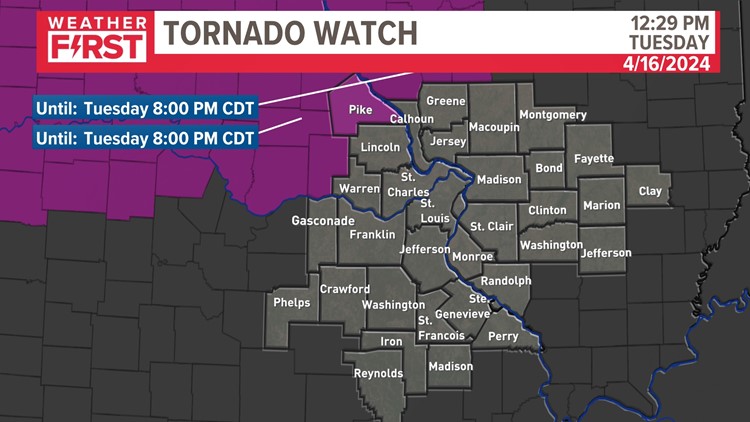
The NWS also issued a Tornado Watch for Pike County until 8 p.m., which will likely continue because there is a chance a rogue storm may pass through northwest Missouri counties Tuesday evening.
The NWS issued a Wind Advisory for numerous St. Louis area counties through 9 p.m., which will also likely continue. Other affected counties include:
Missouri:
- Audrain
- Boone
- Callaway
- Cole
- Franklin
- Gasconade
- Jefferson
- Knox
- Lewis
- Lincoln
- Marion
- Moniteau
- Monroe
- Montgomery
- Osage
- Pike
- Ralls
- Shelby
- St. Charles
- St. Louis
- St. Louis City
- Warren
Illinois:
- Adams
- Bond
- Brown
- Calhoun
- Clinton
- Fayette
- Greene
- Jersey
- Macoupin
- Madison
- Marion
- Monroe
- Montgomery
- Pike
- St. Clair
- Washington
The stage was set for potential severe storms when springtime warmth surged back into St. Louis over the past weekend.
High temperatures reached 89 degrees at St. Louis Lambert on Sunday afternoon. Expect an uptick in humidity on Monday and Tuesday to produce a few thunderstorms. Along with the warmth ahead of this system, moisture will be drawn north from the Gulf of Mexico. Expect moisture-rich air as this weather system moves into our region on Tuesday.
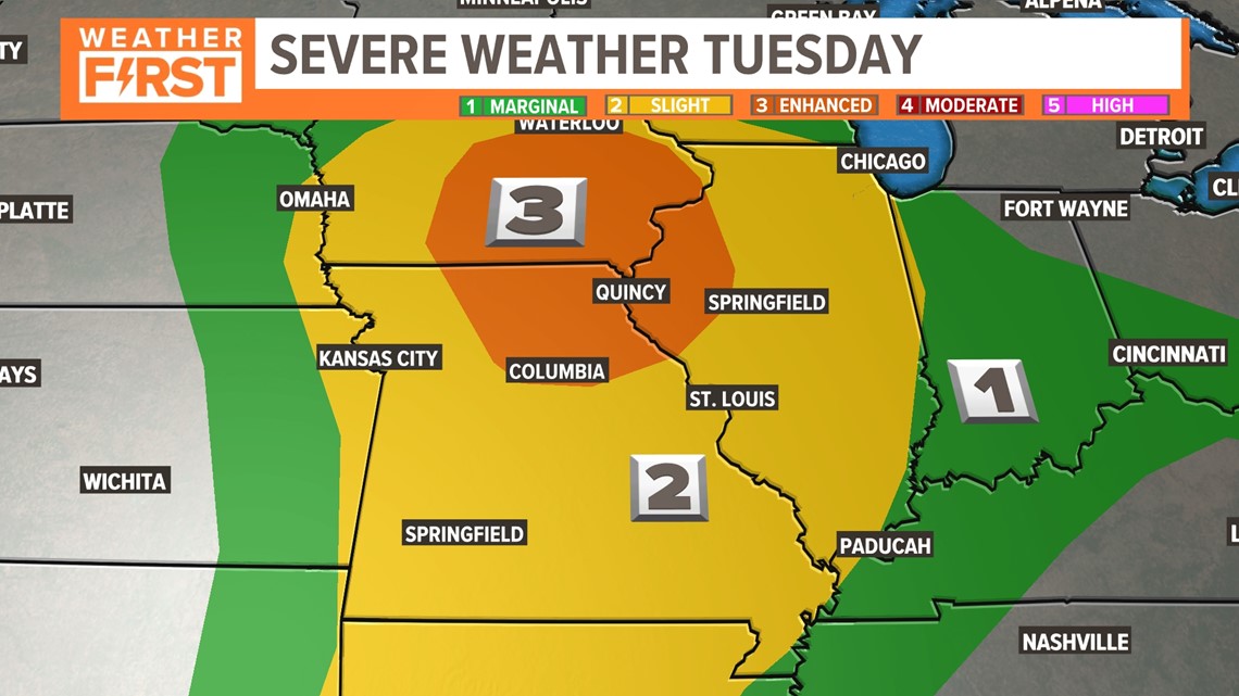
The Storm Prediction Center highlights a good portion of the Mississippi River Valley for the potential of strong to severe thunderstorms.

Download the free 5 On Your Side app to get the latest watches and warnings and track conditions live with our interactive radar. Use the links below to download now.
5 On Your Side news app
iPhone | Google Play
The Weather First Team will use "Storm Alert" to refer to life-threatening or major-impact weather conditions in our region. "Weather Alert" refers to nuisance or disruptive weather and is indicated by orange icons and bars in our weather graphics on TV and online.
In Missouri, we serve these counties: Crawford County, Franklin County, Gasconade County, Iron County, Jefferson County, Lincoln County, Madison County, Perry County, Phelps County, Pike County, Reynolds County, St. Charles County, St. Francois County, St. Louis City, St. Louis County, Ste. Genevieve County, Warren County, and Washington County.
In Illinois, we serve Bond County, Calhoun County, Clay County, Clinton County, Fayette County, Greene County, Jefferson County, Jersey County, Macoupin County, Madison County, Marion County, Monroe County, Montgomery County, Randolph County, St. Clair County, and Washington County.
To watch 5 On Your Side broadcasts or reports 24/7, 5 On Your Side is always streaming on 5+. Download for free on Roku or Amazon Fire TV.